
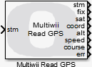
Multiwii Read GPS
Reads the raw GPS data.
Library
QUARC Targets/Communications/Multiwii MATLAB Command Line Click to copy the following command line to the clipboard. Then paste it in the MATLAB Command Window: qc_open_library('quarc_library/Communications/Multiwii')
Description
The Multiwii Read GPS block uses the Multiwii protocol on the input stream to send a command to the aircraft to
read the raw GPS data from the auto-pilot. The Multiwii Read GPS block sends a MSP_RAW_GPS
message to the auto-pilot.
This block is designed to be used with blocking I/O. It is typically used with a stream connected to a serial port. To open the stream a Multiwii Connect block should be used.
The outputs of the block are whether there is a GPS fix, the number of satellites, the latitude and longitude coordinates, the altitude, the speed and the ground course.
A copy of the stream is also output so that the Multiwii blocks may be chained together.
If an error occurs, then the block returns a negative error code at its err output. The Compare to Error block may be used to check for specific error codes. If the stream is not valid because it is not yet connected, the err output will be zero since this condition is expected and the validity of the stream may be checked using the con output of the Multiwii Connect block.
Helpful Hints
Other uses of this block
 Although it is intended for use in the main diagram with the other Multiwii
blocks, the
Multiwii Read GPS
block may be used
with the Advanced stream blocks, even in an asynchronous thread.
Although it is intended for use in the main diagram with the other Multiwii
blocks, the
Multiwii Read GPS
block may be used
with the Advanced stream blocks, even in an asynchronous thread.
Input Ports
stm
A reference to the stream created by the Multiwii Connect block. If a connection has not yet been established, then the err output of the Multiwii Read GPS block will be zero.
Output Ports
stm
A reference to the stream. This output is merely a copy of the stm input. Providing this output makes it much easier to establish the execution order of Multiwii blocks in the diagram because Simulink generally executes daisy-chained blocks in sequence.
fix
A boolean value indicating whether a GPS fix has been obtained.
sat
A uint8 integer containing the number of satellites upon which the GPS measurements were made.
coord
A 2-vector containing the latitude and longitude coordinates respectively in radians.
alt
A scalar representing the altitude in metres.
speed
A scalar representing the speed in metres per second.
course
A scalar representing the ground course in radians.
err
An int32 value indicating whether the data was read successfully. This value will be positive if data was read successfully. It will be zero if data could not be read immediately. If an error occurs then this value is a negative error code. See Error Codes for the different error codes and their values. Use the Compare to Error block rather than the error code itself to check for specific error codes. To check for errors in general use the Compare to Zero block to check whether the err output is less than zero.
Parameters and Dialog Box
The Multiwii Read GPS block has no parameters.
Targets
|
Target Name |
Compatible* |
Model Referencing |
Comments |
|---|---|---|---|
|
Yes |
Yes |
||
|
Yes |
Yes |
||
|
Yes |
Yes |
||
|
Yes |
Yes |
||
|
Yes |
Yes |
||
|
Yes |
Yes |
||
|
Yes |
Yes |
||
|
Yes |
Yes |
||
|
Yes |
Yes |
||
|
Yes |
Yes |
||
|
Yes |
Yes |
||
|
Yes |
Yes |
||
|
Yes |
Yes |
||
|
Yes |
Yes |
Last fully supported in QUARC 2018. |
|
|
Rapid Simulation (RSIM) Target |
Yes |
Yes |
|
|
S-Function Target |
No |
N/A |
Old technology. Use model referencing instead. |
|
Normal simulation |
Yes |
Yes |
See Also
Copyright ©2026 Quanser Inc. This page was generated 2026-05-13. Submit feedback to Quanser about this page.
Link to this page.